PIX4Dcloud
Effortless Cloud Mapping & Digital Site Capture
PIX4Dcloud converts your photos and scans into detailed 2D and 3D outputs automatically — processed online and ready to share instantly.
Produce survey‑ready deliverables; monitor project changes; and collaborate in real time — all without installing desktop software.
An ideal platform for teams in construction; utilities; civil engineering; insurance; and surveying who rely on fast; dependable data.
Why Buy PIX4Dcloud from Innovelec?
✅ Authorised PIX4D Partner
✅ UK-Based Technical Support
✅ Fast Digital Licence Delivery
✅ Advice on Starter vs Pro Plans
✅ Support for Construction; Utilities & Surveying
✅ Phone & Email Assistance
PIX4Dcloud Outputs & Analysis
PIX4Dcloud works with data captured from drones; PIX4Dcatch; RTK-enabled mobile devices and traditional photogrammetry workflows.
Heritage Asset Documentation Example – Captured using PIX4DCatch
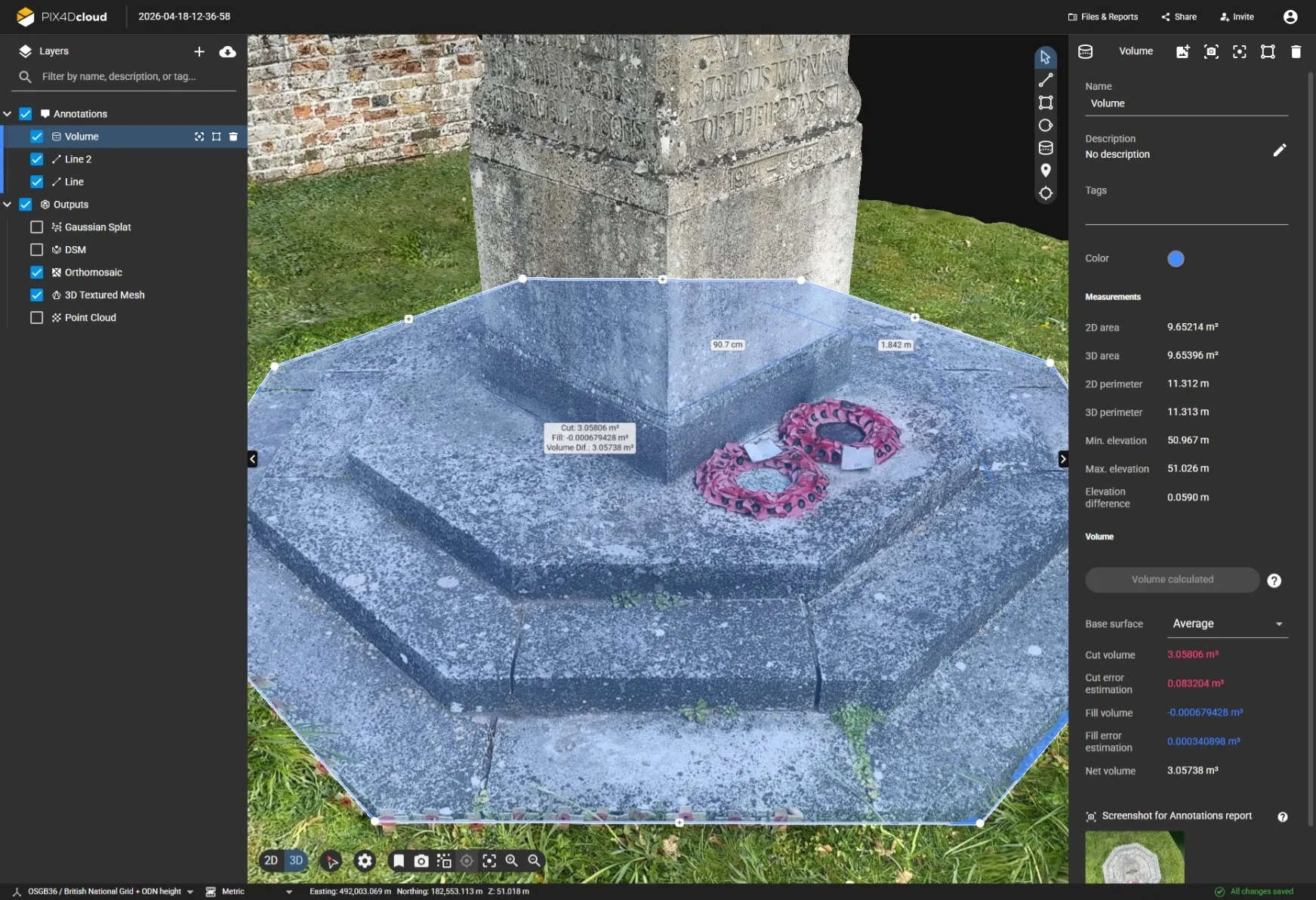
See real PIX4Dcloud outputs created from imagery captured with PIX4Dcatch. This project demonstrates browser-based 3D modelling; measurements and orthomosaic generation from a heritage asset documentation survey.
3D Model
Heritage Asset Documentation Example Processed in PIX4Dcloud This example was captured using PIX4Dcatch and processed in PIX4Dcloud to generate a textured 3D mesh; orthomosaic and measurement-ready outputs directly in the browser.
Generate detailed textured 3D models directly from drone or mobile mapping imagery.
Measurement & Annotation
Measure areas; distances and elevations directly within PIX4Dcloud using browser-based analysis tools.
Measure areas; distances and elevations directly within PIX4Dcloud.
Orthomosaic / Top-down View
Produce accurate orthomosaic maps for inspection; documentation and asset management workflows.
Produce accurate orthomosaic for inspection; documentation and asset management.
High‑Quality Photogrammetry; Straight From the Browser
- Generates orthomosaics; point clouds; textured meshes; and elevation models from drone or ground‑based imagery.
- Works seamlessly with RTK data and GCPs to ensure centimetre‑level accuracy when required.
Streamlined; Guided Cloud Workflows
PIX4Dcloud provides tools designed for consistency and repeatability:
- Automated processing templates for predictable results.
- Timeline features for viewing and comparing site evolution over time (Pro).
- 2D and 3D design overlays (DXF / IFC) to validate projects against plans (Pro).
Distributed teams can produce uniform; reliable outputs regardless of where they work.
Instant Quality Control = Fewer Return Visits
Quality checks built into the cloud workflow include:
- Image quality and overlap verification.
- Automated accuracy and processing reports.
- Clear visual inspection tools in both 2D and 3D environments.
Teams can confirm dataset completeness before they ever leave the field.
Flexible Processing & Smooth Integration
Use PIX4Dcloud how it best supports your workflow:
- Upload images for automatic cloud processing with no local resources needed.
- Export processed results into CAD; BIM; and GIS ecosystems such as Trimble and ESRI.
- Connect effortlessly with PIX4Dmatic; PIX4Dmapper; and PIX4Dcatch for hybrid aerial/terrestrial workflows.
A seamless path from data capture → cloud processing → actionable deliverables.
Ideal Use Cases
Utilities & Subsurface Mapping
- Document trenches; buried utilities; and asset locations with precise visual records.
- Maintain continuously updated site documentation throughout the project lifecycle.
Construction & Earthworks
- Review construction progress using timeline comparison tools (Pro).
- Calculate stockpile volumes; cut/fill changes; and other earthwork metrics.
- Overlay IFC/DXF files to confirm whether work aligns with design intent.
Civil Engineering & Site Verification
- Check real‑world conditions against CAD models for compliance.
- Validate grading; excavation; utilities installation; and alignment quickly.
Insurance & Claims
- Capture clear; defensible 2D and 3D documentation for claims and assessments.
- Produce measurable and shareable evidence for adjusters and stakeholders.
Surveying & Geospatial Work